

Zones
 A Zone (
Z) restricts a takeoff to part of a sheet. Draw a boundary
around an area and PixelTakeoff reports quantities for what falls inside it.
Use zones when one drawing covers work that has to be reported separately: phases, blocks, plots, villa types, or a split between two contractors. You take off the whole sheet once, then read it back per zone rather than measuring the same drawing several times.
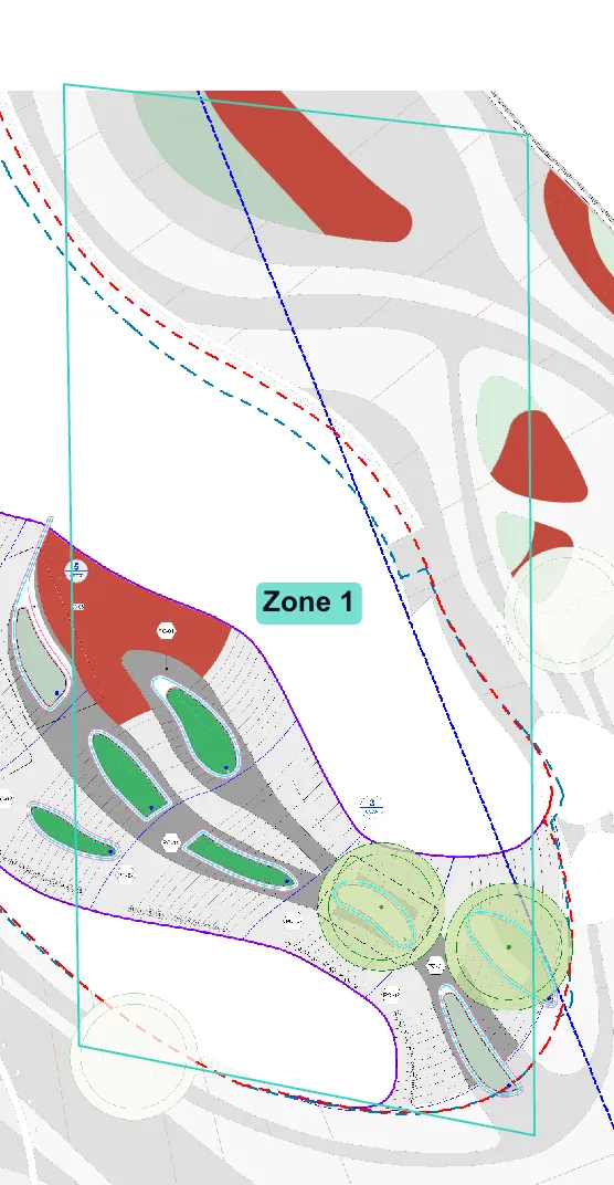
The takeoff was already done when this zone was drawn. Some areas sit wholly inside it and count in full, while others are cut by the boundary and count only in part. Those are the ones that come back marked clipped when you read the quantities.
Drawing a zone
Section titled “Drawing a zone”- Select Zone (
Z). - Click around the area you want to enclose, one point per corner.
- Close the shape to finish.
Zones can be any shape, including concave ones such as an L shaped plot, so you do not have to settle for a rectangle around something irregular.
A zone sits over your takeoff. It does not change, move or delete anything you have measured, so drawing one is always safe.
Reading zone quantities
Section titled “Reading zone quantities”The Zones window lists every group with quantity inside the zone, with a preview of the zone itself beside the table so you can see what you are reading:
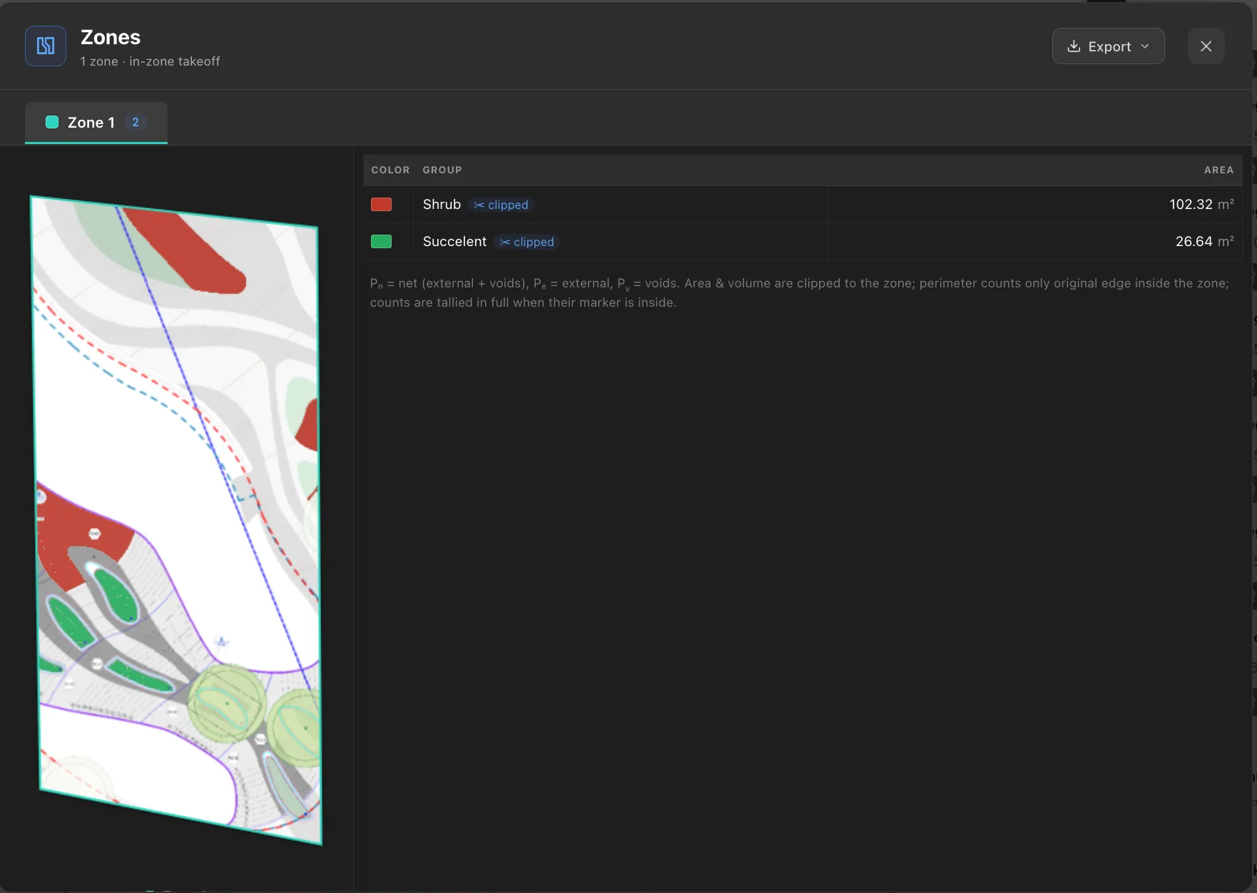
Each zone gets its own tab along the top, with the number of groups inside it on the tab, so a sheet split into phases is a row of tabs you can click through. Export in the corner takes the zone quantities out for reporting.
| Column | Meaning |
|---|---|
| Color | The group’s colour, for matching against the drawing |
| Group | The takeoff group name |
| Area | Area inside the zone |
| Length | Linear length inside the zone |
| Count | Count markers inside the zone |
| Volume | Volume inside the zone |
Columns appear as they apply, so a zone containing only areas shows only an area column.
Only groups with something inside the zone appear, so the list is a summary of that phase rather than of the whole sheet.
A ✂ clipped badge beside a group name means that group crosses the zone boundary and what you are reading is the part inside. A group with no badge sits entirely within the zone, so its zone quantity is its whole quantity. The badge is worth a glance before reporting, because it tells you which numbers depend on where you drew the line.
How quantities are attributed
Section titled “How quantities are attributed”This is the part worth understanding, because it is what makes zone totals trustworthy.
A region entirely inside a zone counts in full. No estimation is involved. Its quantity in the zone is exactly its quantity on the sheet.
A region crossing the boundary is split. Area and volume are both cut to the zone, so only the part inside is counted. The paving of a driveway that straddles two phases contributes its inside portion to each, and the two portions add back up to the whole driveway.
A linear run crossing the boundary is split the same way. Only the length inside counts.
A count marker counts if its centre is inside. Markers are whole items, so they are never split. A tree on the boundary belongs to the zone its marker centre sits in.
Perimeter counts only the real edge. This one surprises people. When a zone cuts through a region, the line the zone made is not treated as perimeter. Only the region’s own boundary, the part of it that falls inside the zone, is counted. Pₙ, Pₑ and Pᵥ all follow that rule.
That is deliberate, and it matches what you would price. You do not edge a paving area along an invisible line where a phase boundary happened to fall, so that length should not appear in an edging quantity. It does mean the perimeters of two zones will not add up to the perimeter of the whole region, and that is correct rather than a rounding problem.
Overlapping zones
Section titled “Overlapping zones”If two zones overlap, anything in the shared area is counted once, and it is attributed to the zone you drew first.
This is deliberate. If shared ground counted in both, adding your zone totals together would exceed the real quantity on the sheet, and you would over order and over bill. With earlier zone wins, the zone totals always add up to the whole.
A practical workflow
Section titled “A practical workflow”- Take off the entire drawing normally, ignoring phases.
- Draw a zone around each phase.
- Read each zone’s quantities and report them separately.
The advantage over measuring each phase separately is that the sheet is measured once, so the total across zones cannot disagree with the total for the drawing.
Common questions
Section titled “Common questions”Does a zone change my takeoff? No. It is a lens over work you have already done. Delete a zone and your takeoff is untouched.
Can a region be in more than one zone? Yes, if it crosses a boundary. Its quantity is split between them and the parts add up to the whole.
Why is a zone total lower than I expected? Check whether a region you assumed was inside actually crosses the boundary, in which case only part of it counts. Also confirm no group is hidden, since hidden groups are excluded from totals everywhere.
Why do my two zone perimeters not add up to the whole? Because the cut line a zone makes is not counted as perimeter. Only real edge counts, so splitting a region across two zones loses the length of the join, which was never a real edge to begin with.
Can I export per zone? Yes, with Export in the Zones window.